Grizzly Peak Vegetation Management Project
Grizzly Peak Mitigation Area • Very High Fire Hazard Severity Zone • High Fire Hazard Severity Zone
This program is currently paused. Any updates on resuming will be reflected here.
We are making Grizzly Peak safer from wildfires.
Thanks to a grant from CAL FIRE, we are conducting vegetation mitigation work along Grizzly Peak rights-of-way, which serves as the primary evacuation route for residents in the area.
In 2025, we are focusing on removing dead and dying vegetation that is most likely to ignite during a wildfire to protect the more than 29,000 structures. Removing and clearing certain areas in Grizzly Peak will help create a fuel break between the remaining vegetation. This fuel break prevents fires from spreading quickly and ensures that evacuation routes away from Grizzly Peak will remain clear in the event residents must evacuate quickly.
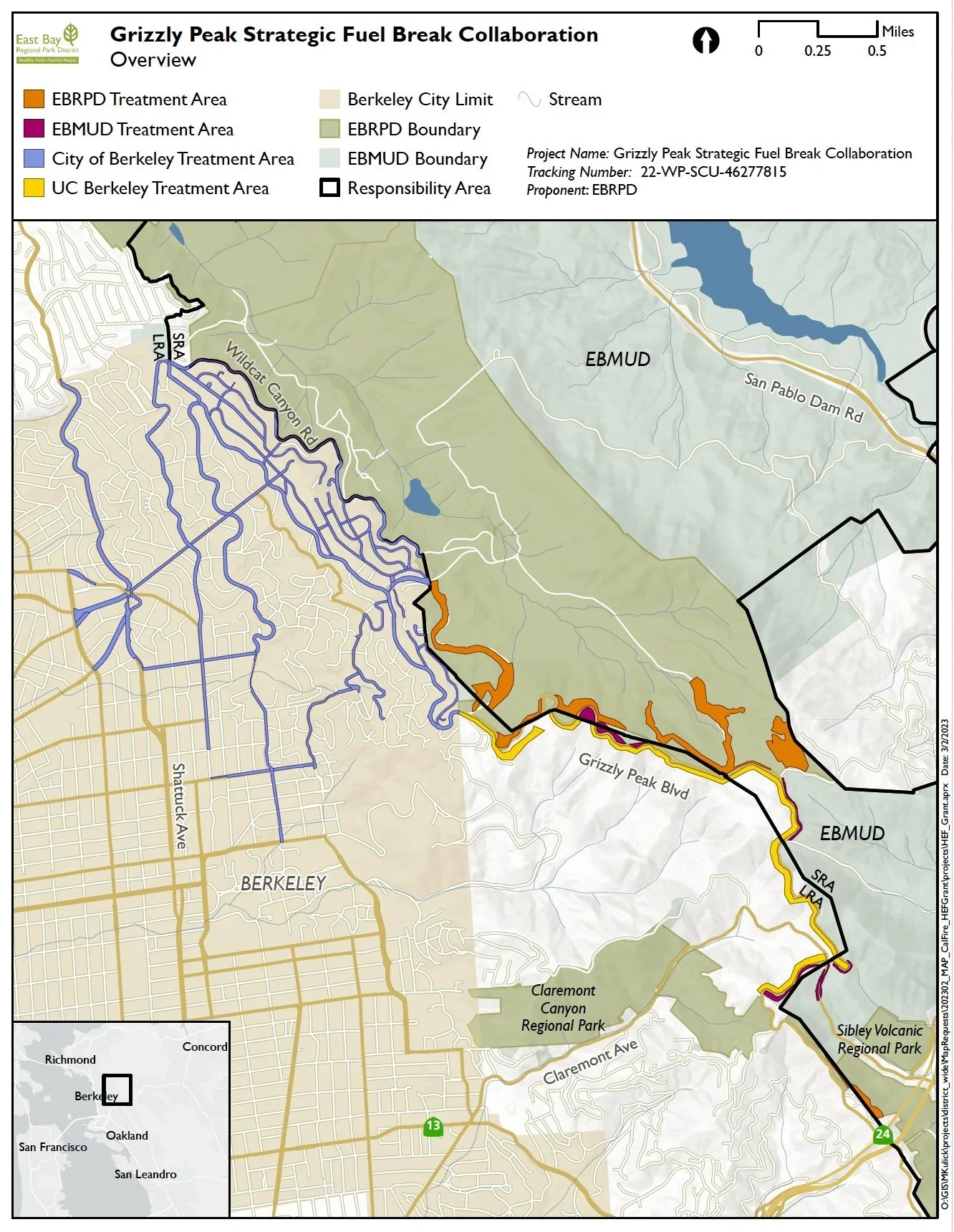
This is a collaboration with East Bay Municipal Utilities District (EBMUD), UC Berkeley, Berkeley Fire Department, and East Bay Regional Park District (EBRPD).
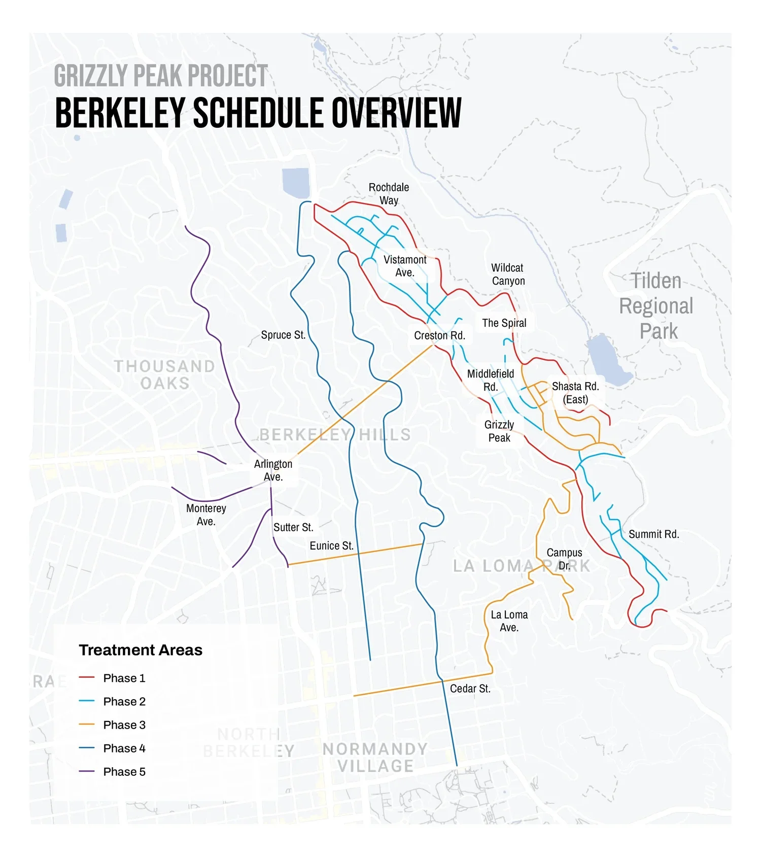
The City of Berkeley fuel modification project includes 110.331 acres along 40.44 miles of roadway.
What we are removing entirely and why
BFD contractors will remove specific hazardous vegetation that shares one or more of the following characteristics:
Biologically prone to burn due to chemical composition (which often means it contains volatile oils), difficult to maintain, may have a surface area prone to fire, or tends to rapidly adapt to the surrounding air moisture, which as firefighters we call 1-hour, or light flashy fuels. The most hazardous of these species contain ALL of these characteristics.
Generally, native, non-hazardous vegetation will not be removed, but it will be pruned or reduced in density if it is particularly large.


Where are we removing the fire-hazardous vegetation
BFD contractors will remove hazardous vegetation within 10 feet of the public right-of-way of the roadway.
Section 4906.5.5 Clearance of Brush or Vegetative Growth from Roadways:
The fire code official is authorized to cause areas within 10 feet (3048 mm) from the edge of the pavement on each side of portions of highways, streets and private roads which are improved, designed or ordinarily used for vehicular traffic to be cleared of flammable vegetation and other combustible growth. The fire code official is authorized to enter upon private property to do so.
How will I be notified about work near my home and if my plants are affected?
BFD inspectors will be distributing door hangers to provide; dates of anticipated work, inspection access codes, and a link to the plant replacement and preferences form.
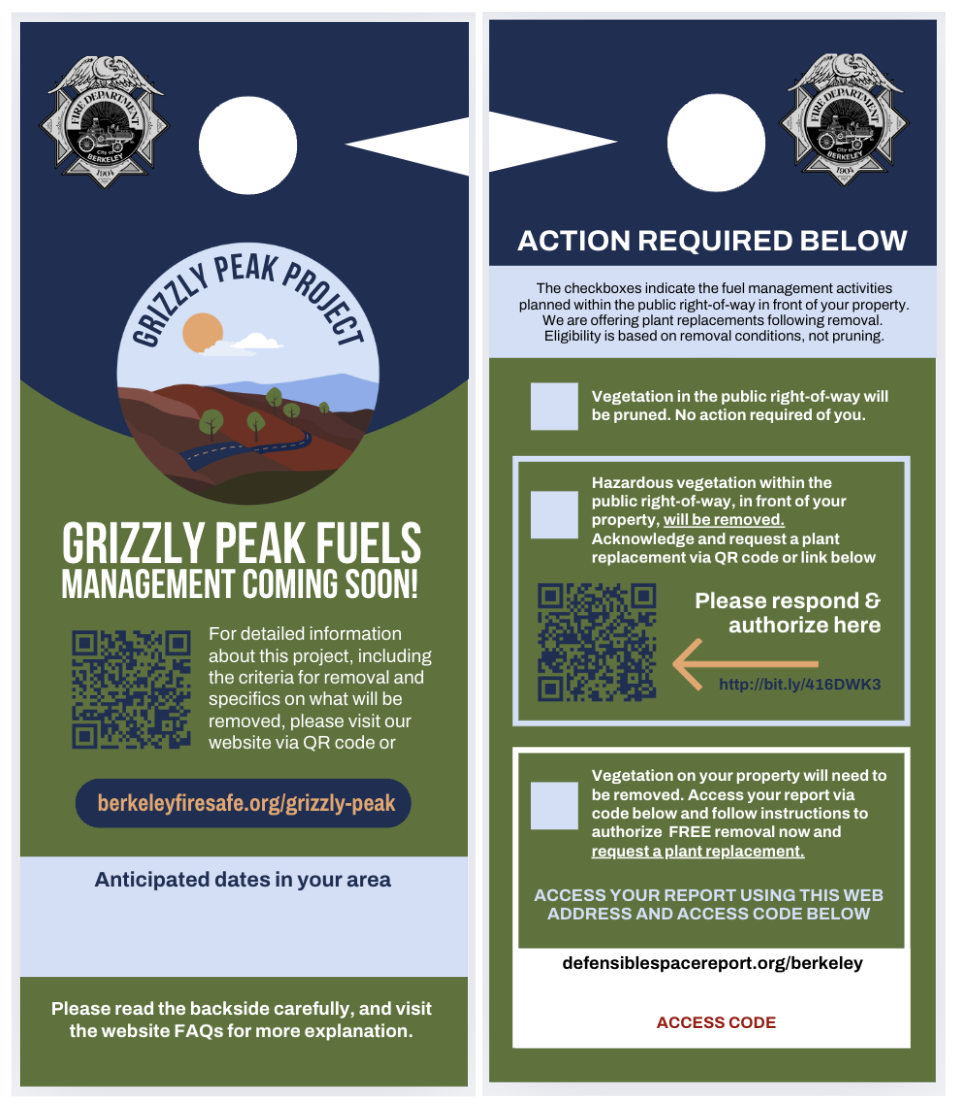
The door hanger that we are distributing provides an inspection code for residents who have the above described privacy hedges and a form to complete. The form allows you to select your preference for removing the privacy hedge yourself at a later date, or having our contractors do it now (which makes you eligible the free plant replacement program).
Note: Hazardous vegetation that is in the public right of way (such as between the side walk and the street, or adjacent to utility poles), does not require resident permission and will be pruned or removed.
If vegetation was recently removed from your property as part of the Grizzly Peak Vegetation Management Project, you may be eligible to receive free replacement plants. The Plant Replacement Program offers eligible residents scheduled plant pick-up days, where they will receive a voucher to redeem for a selection of approved replacement plants.
Eligibility is based on hazardous vegetation removal, not pruning
Project Status Updates


Phase 1 started on February 17, 2025
Wildcat Canyon Rd: Removed 122.4 tons of vegetation (1.8 miles total)
Grizzly Peak Boulevard: Removed a total of 516 tons of vegetation (2.28 miles)
Phase 2 started on June 16, 2025
44.8 tons of vegetation removed from Phase 2 (3.24 miles completed)
Phase 2 included the following in order:
Rochdale Way, Rosemont Ave, Vistamont Ave, Woodmont Ave, Woodmont Ct, Sunset Ln, Marin Ave (East), The Spiral, The Shortcut, Middlefield Rd, The Crossways, Overlook Rd, Lantham Ln, Park Gate, Shasta Rd, Hill Rd (North), Hill Rd (South), Atlas Pl
Phase 3 started on August 13, 2025
Phase 3 included the following in order:
Park Hills, Woodside, Hillview, Cresent
Grizzly Peak Project paused in Fall 2025
The initial CAL FIRE grant was fully expended as planned. Our staff are now actively seeking additional funding to complete the remaining phases of the project. The original grant application included funding to finish the full fuel break; however, CAL FIRE requested a reduction in project scope, resulting in an award approximately $300,000 lower than requested, with a total grant of $448,000. As a result, the project is currently on pause while we pursue new funding sources needed for completion. We remain committed to seeing this important work through to its conclusion and will provide further updates as new resources are secured.
FAQS
-
The program was paused in the Fall of 2025 near the completion of Phase 3. Any updates on resuming will be reflected here.
-
The public right of way includes the street, and the areas to either side of the street that are reserved for pedestrian traffic, utilities, and parking. If you are looking for where the public right of way extends to, look for sidewalks, utility poles, utility access covers, and other similar features. These are all landmarks that are within the public right of way. For the Grizzly Peak project, the right of way is 10 feet from the edge of the street.
-
The City has the authority and obligation to remove any hazardous materials that impede on the public right of way, even if they are on private property.
Privacy hedges that are identified by inspectors will need to be removed as a part of this effort and residents will be notified. Property owners can choose to remove them on their own or can give us permission to remove them when contractors are available and in their area. To give us permission, fill out the form here.
Residents who give us permission to remove privacy hedges now will be eligible for the free plant replacement program. Fill out the form here.
Wooden fences and other improvements being used for privacy that would impede public access during an evacuation will be tagged and evaluated at a later date with appropriate city staff to determine if they infringe on the public right of way.
-
Removal:
Bamboo, juniper, Cypress, pampas grass, rosemary, and other highly combustible vegetation including grasses and weeds within 10 feet of roadways.
Dead or dying trees, shrubs, palm fronds, and other dead vegetation.
Scattered twigs, branches, leaf litter, logs, and other debris.
Pruning:
Pruning tree and shrub limbs around utility lines and power drop lines.
Pruning trees and shrubs to provide at least 13’ 6” of vertical clearance above roads or walkways.
Pruning ground vegetation from under trees to provide a vertical separation of 3 times the height of the understory.
Pruning trees from the ground to 1/3 of their height or 8 feet.
Pruning trees and shrubs to provide a horizontal separation in between them.
Both cypress and rosemary have a high surface area, and volatile oils. They both retain dead, highly flammable material, and are difficult to regularly maintain. Bamboo, Juniper, and Pampas Grass are the other species we will generally be targeting.
-
Learn more about our plant replacement program and apply.
-
Berkeley residents in Fire Zones 2 and 3 are required to maintain 100 feet of defensible space from any structure to help keep their properties safe and prevent wildfires from spreading. If you’re not in Fire Zone 2 or 3, there’s still a lot you can and should do to help make your property safer.
Check out our resources on home hardening, defensible space, and what you can do to help protect yourself and your neighbors in the City of Berkeley.
-
All participating agencies jointly applied for grant funding and the City of Berkeley was awarded $448,000 total for our scope of work. We have also jointly applied for and hope to receive an additional $300,000 in funding for COB via the California ICARP grant program.
-
We conducted a California Environmental Quality Act (CEQA) review and received an exemption for this work. Biological monitoring begins two weeks before vegetation reduction starts -- depending on the season.
Collaborating Agencies


Each agency is responsible for a different, but related, scope of this project. Below are summares of work the collaborating agencies plan to do. For more information about thier portions of this project see their official websites.
-
UC Berkeley’s portion of the proposed project will include grass/shrub mitigation, limbing of trees, as well as removal of potential hazardous trees and debris that could obstruct the roadway. The work will provide improved emergency ingress and egress and remove hazardous vegetation within 100 feet of the roadway.
Work will be performed on University land along Grizzly Peak Blvd. from Marlborough Terrace to the intersection of Grizzly Peak Blvd. and Centennial Dr. The project will increase the protection of some of the campus’ most prominent and public sites, including Lawrence Hall of Science, UC Botanical Garden, Station of Behavioral Research, and the various Ecological Study Areas adjacent to the roadway.
In these evacuation support treatment areas, UC Berkeley removes lower branches of all trees to a minimum height of 8 feet, and understory vegetation. Shrubs are removed or thinned to a minimum spacing of 6 feet. Surface vegetative fuels may include short shrubs with little dead material, leaf litter, annual and perennial grass. Taller shrubs may be present well away from a tree canopy. Grass has been and will be cut every fire season within 100 feet of the pavement edge of Grizzly Peak Blvd. Branches hanging over roadbeds or fire trails are trimmed to a height of 15 feet above ground. Trees that may obstruct the roadway will be removed. Dead surface fuels smaller than six inches in diameter are removed. Leaf litter of less than six inches in depth is typically left and dead trees are removed. Chips will cover most surfaces within the area upon completion of the treatment; in this treatment area chip depth can be as deep as six inches.
Maintenance of these areas will be incorporated into UC Berkeley’s Annual Defensible Space and Roadside Treatment Plans. The maintenance work will be performed primarily with hand-held equipment with the option of grazing herds being utilized on some of the most difficult terrain. This portion of the project, together with other grant participants, will establish and maintain a five mile plus continuous fuel break.
-
East Bay Municipal Utility District’s fuel modification project includes 10.69 acres along 2.66 miles of roadway. Designed to protect residents in the communities of Berkeley, Oakland, and Orinda by modifying wildfire fuels in a strategic manner designed to minimize watershed impacts and protect habitat values.
Fuel modification includes thinning the brush and trees within 100 feet of the edge of the roadway to reduce the spread of wildfire from a roadside ignition, while leaving sufficient cover to suppress invasive plant colonization.
Questions: Call EBMUD Watershed Headquarters, 510.287.0459
-
The East Bay Regional Park District's fuels management project aims to significantly reduce wildfire risk and enhance emergency access and evacuation capabilities by connecting to and filling in the gaps between existing fuels reduction projects in the area of Grizzly Peak Boulevard. Six areas located in Tilden and Sibley Regional Parks will be targeted to protect the communities of Berkeley, Oakland, and Orinda.
Hazardous wildland fuels will be treated in a manner consistent with our Wildfire Hazard and Resource Management Plan and the East Bay Hills CalVTP, resulting in reduced wildfire risk and increased resilience to future threats of wildfire. This will be achieved by reducing brush and ladder fuels, thinning dense stands of trees, promoting fire-resilient species and biodiversity, and preventing the colonization and establishment of invasive weeds.
Click here for further information about our Fuels Management.